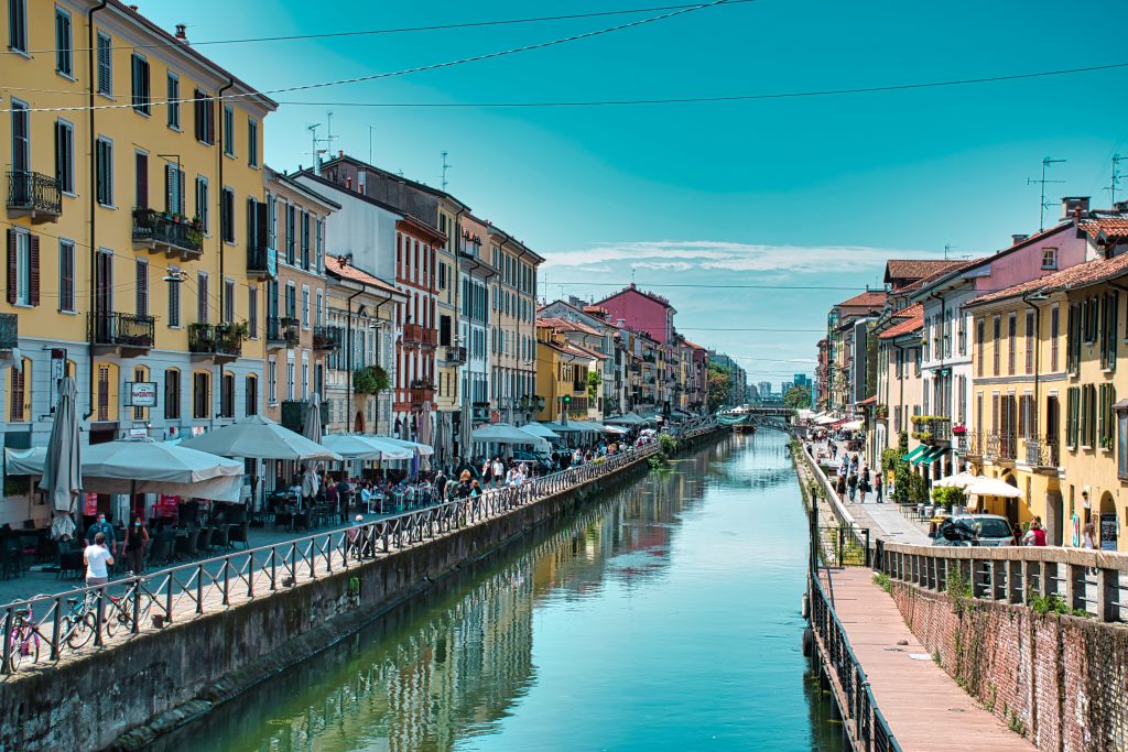
Memories of Milan bring images of the Duomo and Via Montenapoleone to mind, art and fashion remaining two of the reasons people like the city so much. But if you’ve visited, and especially if you’ve lived there and enjoyed your evenings and weekend the way locals do, then you must be fond of the navigli, Milan’s own canals.
Water isn’t the first thing that springs to mind when thinking about Milan: contrarily to other major cities in Italy and the world, the Lombardia capital wasn’t built around a river. There is no Po nor Tiber, no Thames nor Seine here. As early as the 12th century, in 1177, however, the Naviglio Grande, or Grand Canal, was inaugurated, making of it one of the oldest navigable canals in the continent: the Milanese understood how important waterways could be for their welfare and their economy. Today, the Naviglio Grande is the heart of Milan’s “movida,” the world of aperitivi and Dolce Vita alla Milanese, that so many missed during the pandemic, but its importance has been all economic and strategic for centuries: it was at the heart of a complex system of canals and waterways not much different from what we can still see today in Venice or Amsterdam.
The aim was to increase the city’s wealth and visibility and to make it better connected. And so, between the 12th and the 17th century, the navigli network was born and developed, also with the considerable help of iconic Leonardo, who did come out with an idea or two on how to make the system more efficient. In the 15th century, the navigli network connected the city to the Ticino River west and the Adda river east, while at its heart was the Cerchia Interna, or inner ring, a series of smaller navigli keeping together the whole system. Today, only a few vestiges of this glorious water network are still visible in the Navigli area, of course, and in the North of Milan, with the Martesana canal: everything else fell victim to time and progress, with most of the other canals being covered in concrete around the mid 20th century. They are still there, running underneath the surface of the city, but not many remember them anymore.
A view of the Navigli. Photo: Balazs Sebok/Dreamstime
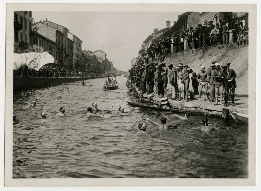
In recent years, another famous area of the navigli system was rescued from oblivion, the Darsena, or “dock.” Located at the junction between Naviglio Grande and Naviglio Pavese, in the past it was, believe it or not, one of the busiest ports in the country, used to transport goods of all kinds to Italy’s wealthiest city. In fact, it was here at the Darsena that boats filled with marble from the quarries of Candoglia would dock, their precious content to be used for the construction of Milan’s most iconic landmark, the Duomo. This went on up until the 1920s.
The Darsena was eventually decommissioned in the 1960s. Quickly, the area fell in disrepair and laid abandoned for decades, until 2015, when it was renovated in occasion of the Milan Expo. Today, the Darsena is active part of the city’s navigli borough, and it’s characterized by its many cafés, stores and restaurants. After the requalification of the Darsena, boat services– a smaller version of Paris’ famous bateaux mouches– has taken up, too: boats sail along the Naviglio Grande and dock at the Darsena, offering both an occasion to see Milan from a different perspective and something to look at while sitting with your Negroni along the canal.
The success of the “new” Darsena brought many to think it may be time to rediscover the navigli system in its entirety, by fully reopening Milan’s Cerchia Interna, today mostly running underground.
A project was presented in 2019, with the aim of completing it by 2026, just in time for the Winter Olympics Milan will co-host with Cortina d’Ampezzo. The idea is to reopen about 5 miles of canals, running from Cassina di Pomm (north of the city) to the Darsena (in the south), following the path of Milan’s medieval waterway system.
The project is strong and has the support of the local community, as the presence of organizations such as Riaprire i Navigli bears witness to. Indeed, recreating the Inner Circle would also be a way to requalify large areas of the city and to reduce, according to some, traffic and pollution. And while the project is undoubtedly ambitious, the example set by the Dutch city of Utrecht, whose circular waterway – covered, just like the Inner Circle during the 20th century – has been recently reopened, strengthens the hopes of supporters.
The next big thing is finding sufficient funds to carry out the project: a sum of around 500 million euro (or 610 million USD) is thought to be necessary, but the increased interest in the navigli could be a strong selling point to obtain relevant financing. Because the project could potentially bring together the city’s necessity for more green spaces, and also offer employment opportunities, a request to use some of the coronavirus recovery fund the EU will give Italy has been submitted, with specific plans currently being created by a Milanese engineering firm.
I ricordi di Milano portano alla mente immagini del Duomo e di via Montenapoleone, l’arte e la moda che rimangono due delle ragioni per cui la gente ama così tanto la città. Ma se l’hai visitata, e soprattutto se ci hai vissuto e ti sei goduto serate e weekend come fa la gente del posto, allora devi essere affezionato ai navigli, i canali di Milano.
L’acqua non è la prima cosa che viene in mente quando si pensa a Milano: contrariamente ad altre grandi città in Italia e nel mondo, il capoluogo lombardo non è stato costruito intorno a un fiume. Qui non ci sono né Po né Tevere, né Tamigi né Senna. Già nel XII secolo, nel 1177, però, fu inaugurato il Naviglio Grande, facendone uno dei più antichi canali navigabili del continente: i milanesi capirono quanto le vie d’acqua potessero essere importanti per il loro benessere e la loro economia. Oggi il Naviglio Grande è il cuore della “movida” milanese, il mondo degli aperitivi e della Dolce Vita alla milanese, che a così tanti è mancata durante la pandemia, ma la sua importanza è stata tutta economica e strategica per secoli: era il cuore di un complesso sistema di canali e vie d’acqua non molto diverso da quello che possiamo vedere ancora oggi a Venezia o Amsterdam.
Lo scopo era quello di aumentare la ricchezza e la visibilità della città e di renderla meglio collegata. E così, tra il XII e il XVII secolo, nacque e si sviluppò la rete dei navigli, anche con il notevole aiuto dell’iconico Leonardo, che se ne uscì con qualche idea su come rendere il sistema più efficiente. Nel XV secolo, la rete dei navigli collegava la città al fiume Ticino a ovest e al fiume Adda a est, mentre il suo cuore era la Cerchia Interna, o anello interno, una serie di navigli più piccoli che tenevano insieme l’intero sistema. Oggi, solo alcune vestigia di questa gloriosa rete idrica sono ancora visibili nella zona dei Navigli, naturalmente, e nella zona nord di Milano, con il Naviglio della Martesana: tutto il resto è caduto vittima del tempo e del progresso, con la maggior parte degli altri canali che sono stati ricoperti di cemento intorno alla metà del XX secolo. Sono ancora lì, che corrono sotto la superficie della città, ma non molti se li ricordano ancora.
Negli ultimi anni è stata salvata dall’oblio un’altra famosa zona del sistema dei navigli, la Darsena. Situata all’incrocio tra il Naviglio Grande e il Naviglio Pavese, in passato era, che ci crediate o no, uno dei porti più trafficati del Paese, utilizzato per trasportare merci di ogni tipo verso la città più ricca d’Italia. Infatti, proprio qui alla Darsena attraccavano le barche piene di marmo proveniente dalle cave di Candoglia, il cui prezioso contenuto veniva utilizzato per la costruzione del simbolo di Milano, il Duomo. Questo andò avanti fino agli anni ’20.
La Darsena fu infine dismessa negli anni ’60. Rapidamente, l’area cadde in rovina e rimase abbandonata per decenni, fino al 2015, quando fu ristrutturata in occasione dell’Expo di Milano. Oggi la Darsena è parte attiva del quartiere Navigli della città e si caratterizza per i suoi numerosi caffè, negozi e ristoranti. Dopo la riqualificazione della Darsena, ha preso piede anche il servizio di battelli – una versione ridotta dei famosi bateaux mouches parigini – che navigano lungo il Naviglio Grande e attraccano alla Darsena, offrendo sia un’occasione per vedere Milano da una prospettiva diversa sia qualcosa da guardare mentre si è seduti con il proprio Negroni lungo il canale.
Il successo della “nuova” Darsena ha portato molti a pensare che potrebbe essere il momento di riscoprire il sistema dei navigli nella sua interezza, riaprendo completamente la Cerchia Interna di Milano, oggi in gran parte sotterranea.
Un progetto è stato presentato nel 2019, con l’obiettivo di completarlo entro il 2026, giusto in tempo per le Olimpiadi invernali che Milano ospiterà insieme a Cortina d’Ampezzo. L’idea è quella di riaprire circa 5 miglia di canali, che vanno dalla Cassina di Pomm (a nord della città) alla Darsena (a sud), seguendo il percorso del sistema idrico medievale di Milano.
Il progetto è forte e ha il sostegno della comunità locale, come testimonia la presenza di organizzazioni come Riaprire i Navigli. Infatti, ricreare la Cerchia Interna sarebbe anche un modo per riqualificare ampie zone della città e per ridurre, secondo alcuni, il traffico e l’inquinamento. E se il progetto è indubbiamente ambizioso, l’esempio dato dalla città olandese di Utrecht, la cui via d’acqua circolare – coperta, proprio come la Cerchia Interna durante il XX secolo – è stata recentemente riaperta, rafforza le speranze dei sostenitori.
Il prossima grande passo da fare è trovare fondi sufficienti per realizzare il progetto: si pensa che sia necessaria una somma di circa 500 milioni di euro (o 610 milioni di dollari), ma l’accresciuto interesse per i navigli potrebbe essere un forte argomento per ottenere finanziamenti rilevanti. Poiché il progetto potrebbe potenzialmente mettere insieme la necessità della città di avere più spazi verdi e offrire anche opportunità di lavoro, è stata presentata una richiesta per utilizzare parte del fondo per la ripresa post-Coronavirus che l’UE darà all’Italia, con piani specifici attualmente in fase di elaborazione da parte di uno studio di ingegneria milanese.
Unlike many news organizations, instead of putting up a paywall we have eliminated it – we want to keep our coverage of all things Italian as open as we can for anyone to read and most importantly share our love with you about the Bel Paese. Every contribution we receive from readers like you, big or small, goes directly into funding our mission.
If you’re able to, please support L’Italo Americano today from as little as $1.