Have you ever wondered why Italy is divided into regions?
Of course, our regioni are not that different from “counties,” but it’s interesting to see why and how they were created.
Italy was first divided into administrative areas at the time of the first Roman Emperor, the glorious Augustus, who split the peninsula in eleven regions, each indicated by a number rather than a name: some of them looked a lot like our modern regions, others… well, not so much. Take Northern Italy, for example, more precisely the area above and around the Po River: today, we count eight regions, Piemonte, Valle d’Aosta, Liguria, Lombardia, Veneto, Trentino Alto-Adige, Friuli Venezia-Giulia and Emilia Romagna. Back then, though, there were only two: the IX (9th) on the West, going from Valle d’Aosta to the Adda River, and the X (10th), from the Adda River to the Adriatic Sea.
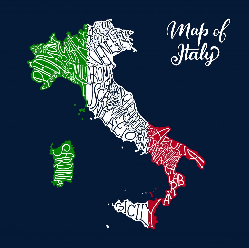
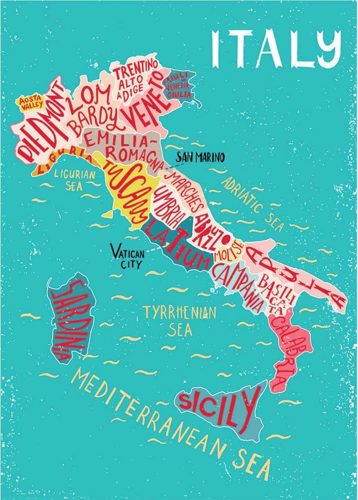
The regions of Italy. Seamartini/Dreamstime.
Now, according to linguists, the word regione, “region,” comes from the Latin verb regere, which means to lead or govern, but Augustus’ regiones didn’t have anything to do with administration and, while today’s Italian regions have specific decisional powers over their own territory, their ancient Roman version did not. Likely, they had been created to facilitate tax collection and census.
After the fall of the Western Roman Empire in 476 AD, the Middle Ages began and Augustus’ provinces disappeared: from then until the Italian Unification, Italy was to be divided in independent states, duchies, signorie, and carved up to please foreign powers – hello, Spain, France and Habsburg Empire.
In 1861, Cesare Correnti, a jurist, and Pietro Maestri, a medical doctor, sat down at a table in Milan and pretty much drew today’s regions on a map: their idea was that of making of these geo-cultural entities, based largely on historical borders and heritage ties, administrative hubs to facilitate the ruling of our newly created unified country. Officially, however, only provinces and communes existed, at least until 1948, three years after the end of World War Two, when regioni where officially instituted in the Costituzione della Repubblica. Back then, though, there were only eighteen and not twenty, as we are used to today: Molise and Friuli Venezia-Giulia were granted regional status in 1963, becoming the youngest regions in the country. Regions, however, didn’t have any administrative and political power until 1970.
Photo: KateChe/Shutterstock
Today, five of Italy’s twenty regions have a statutospeciale,a special status that grants them more autonomy when compared to the others: Valle d’Aosta, Trentino Alto-Adige and Friuli Venezia-Giulia obtained it in name of their particular linguistic characteristics (Valle d’Aosta and Trentino Alto-Adige are bilingual, Friuli Venezia-Giulia counts significant linguistic minorities), Sicilia and Sardegna because they are islands. The regioni a statuto speciale have several administrative and fiscal advantages, including the right to keep all or part of the taxes paid by their residents in the region, instead of sending them to the central administration in Rome. They also have significant decisional power when it comes to the regulation and administration of education, healthcare and transports. The first region of this kind to be instituted was Sicilia, just after the end of the war in 1946; the last was Friuli Venezia-Giulia, in 1963.
Interestingly, all communes in the country, provided their territory lies near a bordering region, have the right to move from a region to another. Since 2000, there were more that 30 local referendums where local citizens were asked if they wanted to become part of another region, but in more than a half of these cases, people just decided they were happy to remain where they were. In fact, since their official administrative creation, only a handful of communes completed the long and cumbersome procedure to”move” from a region to another, including seven villages of the Alta Valmarecchia (from Marche to Emilia-Romagna) and Sappada (from Veneto to Friuli Venezia-Giulia).
Ti sei mai chiesto perché l’Italia è divisa in regioni?
Certo, le nostre regioni non sono molto diverse dalle “contee”, ma è interessante vedere perché e come sono state create.
L’Italia fu divisa per la prima volta in aree amministrative ai tempi del primo imperatore romano, il glorioso Augusto, che divise la penisola in undici regioni, ciascuna indicata da un numero piuttosto che da un nome: alcune di esse assomigliavano molto alle nostre regioni moderne, altre… beh, non tanto. Prendiamo l’Italia del Nord, per esempio, più precisamente la zona sopra e intorno al fiume Po: oggi contiamo otto regioni, Piemonte, Valle d’Aosta, Liguria, Lombardia, Veneto, Trentino Alto-Adige, Friuli Venezia-Giulia ed Emilia Romagna. Allora, però, ce n’erano solo due: la IX (9°) a Ovest, che andava dalla Valle d’Aosta al fiume Adda, e la X (10°), dal fiume Adda al mare Adriatico.
Ora, secondo i linguisti, la parola regione, deriva dal verbo latino regere, che significa guidare o governare, ma le regiones di Augusto non avevano nulla a che fare con l’amministrazione e, mentre le regioni italiane di oggi hanno poteri decisionali specifici sul proprio territorio, la loro antica versione romana non li aveva. Probabilmente erano state create per facilitare la riscossione delle tasse e il censimento.
Dopo la caduta dell’Impero Romano d’Occidente nel 476 d.C., iniziò il Medioevo e le province di Augusto scomparvero: da allora e fino all’Unità d’Italia, l’Italia sarebbe stata divisa in stati indipendenti, ducati, signorie, e divisa per compiacere le potenze straniere: Spagna, Francia e Impero Asburgico.
Nel 1861, Cesare Correnti, un giurista, e Pietro Maestri, un medico, si sedettero attorno un tavolo a Milano e disegnarono su una mappa più o meno le regioni di oggi: la loro idea era quella di fare di queste entità geo-culturali, basate in gran parte su confini storici e legami patrimoniali, degli snodi amministrativi per facilitare il governo del nostro neonato Paese unificato. Ufficialmente, però, c’eranp solo province e comuni, almeno fino al 1948, tre anni dopo la fine della seconda guerra mondiale, quando le regioni furono ufficialmente istituite nella Costituzione della Repubblica. Allora, però, erano solo diciotto e non venti, come oggi: Il Molise e il Friuli Venezia-Giulia ottennero lo status di regioni nel 1963, diventando le regioni più giovani del Paese. Le regioni, tuttavia, non ebbero alcun potere amministrativo e politico fino al 1970.
Oggi, cinque delle venti regioni italiane hanno uno statuto speciale, uno statuto che garantisce loro una maggiore autonomia rispetto alle altre: Valle d’Aosta, Trentino Alto-Adige e Friuli Venezia-Giulia lo hanno ottenuto in nome delle loro particolari caratteristiche linguistiche (Valle d’Aosta e Trentino Alto-Adige sono bilingui, il Friuli Venezia-Giulia conta significative minoranze linguistiche), Sicilia e Sardegna perché sono isole. Le regioni a statuto speciale hanno diversi vantaggi amministrativi e fiscali, incluso il diritto di trattenere tutte o parte delle tasse pagate dai loro residenti nella regione, invece di mandarle all’amministrazione centrale di Roma. Hanno anche un significativo potere decisionale in materia di regolamentazione e amministrazione dell’istruzione, della sanità e dei trasporti. La prima regione di questo tipo ad essere istituita fu la Sicilia, subito dopo la fine della guerra nel 1946; l’ultima fu il Friuli Venezia-Giulia, nel 1963.
È interessante notare che tutti i comuni del Paese, purché il loro territorio sia vicino a una regione confinante, hanno il diritto di passare da una regione all’altra. Dal 2000, ci sono stati più di 30 referendum locali in cui è stato chiesto ai cittadini se volevano accorparsi a un’altra regione, ma in più della metà dei questi casi, le persone hanno semplicemente deciso che erano felici di rimanere dov’erano. Infatti, dalla loro creazione amministrativa ufficiale, solo una manciata di comuni ha completato la lunga e macchinosa procedura per “spostarsi” da una regione all’altra, compresi sette paesi dell’Alta Valmarecchia (dalle Marche all’Emilia-Romagna) e Sappada (dal Veneto al Friuli Venezia-Giulia).
Unlike many news organizations, instead of putting up a paywall we have eliminated it – we want to keep our coverage of all things Italian as open as we can for anyone to read and most importantly share our love with you about the Bel Paese. Every contribution we receive from readers like you, big or small, goes directly into funding our mission.
If you’re able to, please support L’Italo Americano today from as little as $1.