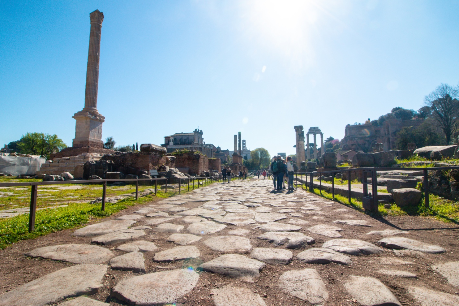
The Roman Forum and the Via Appia (Photo: Zaramira/Dreamstime)

The start of the Via Appia is nothing short of remarkable. You’re in Rome, right in the city center. After leaving the Circus Maximus behind, you navigate the bustling streets, quickly making your way down the grand avenue toward the Baths of Caracalla. You arrive at Piazzale Numa Pompilio, just steps away from the home of Alberto Sordi, the quintessential figure of the “average Italian” in cinema. Marked by a milestone, the road splits, narrows, and greenery begins to replace the concrete, with cobblestones underfoot. On either side are villas, gardens, and walled parks owned by the well-to-do. Then you see the grand travertine arch of Porta San Sebastiano, the largest and best-preserved gate in the Aurelian Walls. Originally called Porta Appia, the gate was named after the Via Appia, which began a bit further back at Porta Capena in the Servian Walls, where the Celian, Palatine, and Aventine hills meet. Today, the first 4 km of that route are no longer visible.

Passing by the concrete tomb of Geta, the brother of Emperor Caracalla (who was named after the Gallic cloak he wore), you soon feel as though you’ve stepped into an ancient stone village. Here, at the junction of the Church of Domine Quo Vadis and the catacombs of San Sebastiano and San Callisto, you find yourself at the dawn of Christianity. An exceptionally well-preserved stretch of the Roman road reveals itself, with countless monuments lining its edges. You reach the complex of Maxentius, with its villa, circus, and mausoleum, and then the circular funerary monument of Cecilia Metella, flanked by a Roman castrum. As the road ascends, you enter a forest of pines and cypresses. By now, the noise of the city traffic has faded. In the heart of chaotic Rome, you walk back in time on smooth, ancient paving stones.

Even through Street View, from the comfort of your home, you can witness how modern and ancient Rome intersect along the Via Appia. Partly adapted to modern needs, with stretches of asphalt, traffic lights, and cars, and partly preserved within the archaeological park, this road offers just three miles of travel yet holds so much wonder: 2,000 years of history lie beneath your feet. The Regina Viarum, the queen of roads—called by the ancients insignis, nobilis, celeberrima (notable, noble, most celebrated)—is one of the greatest feats of ancient civil engineering. Its economic, military, and cultural impact first shaped Roman society and then the entire Western world. It stands as a magnificent bridge between past and present.

In Pompeii, too, you can see this splendid basalt paving, and it’s impossible not to marvel at the advanced road-building techniques of the Romans. While we must not forget the incredible Roman expertise that created bridges, sewers, aqueducts, markets, baths, basilicas, and amphitheaters, we are equally in awe of the concrete tomb of Geta, the arch of Porta San Sebastiano, and the intricate opus reticulatum of Roman walls—a mixture of rubble and mortar that secures the cubilia, pyramid-shaped stone blocks, at a 45-degree angle—all encountered along the first three miles we’ve traveled together.

Roman roads were among the most extraordinary legacies of Roman civilization, essential for trade, Mediterranean expansion, troop movements, and the development of settlements. These roads were 14 feet wide (about 4 meters), enough for two chariots to pass each other in opposite directions. They had three layers: cobblestones for drainage, an intermediate layer of sand and gravel, and a convex surface of stone slabs to allow water to run off. The Romans began paving their roads in the 3rd century BC, and by the 2nd century, basalt paving had spread throughout the urban road system and, during the imperial era, even into rural areas.

UNESCO has recognized the beauty and uniqueness of this monument, designating it Italy’s 60th World Heritage site. The Via Appia connected Rome to Campania (Capua and Benevento), Basilicata (Venosa), and Apulia (Taranto and Brindisi). Yet much remains to be done to protect this vast historical heritage. Construction of the Via Appia began in 312 BC under the orders of the censor Appius Claudius (of the powerful gens Claudia family, which produced 43 consuls and became Rome’s first imperial dynasty) Caecus. The first 30-40 km of the road are still passable, but by the time it reaches Terracina, the route disappears, lost to history and, unfortunately, to neglect. A section reappears in Apulia, but much work is still needed to fully restore this treasure of advanced engineering. This road, once essential for economic, social, and cultural exchanges with the Mediterranean and the East, played a crucial role in shaping the Eternal City we know today.
L’inizio della Via Appia è sorprendente. Sei a Roma, nel centro della città. Ti sei appena lasciato alle spalle il Circo Massimo e, in mezzo al traffico, percorri velocemente il grande viale che porta alle Terme di Caracalla. Arrivi in piazzale Numa Pompilio, a due passi dalla casa di Alberto Sordi, il prototipo cinematografico dell’italiano medio. Segnata da un cippo miliare, la strada si biforca, si restringe, il verde sottrae cemento, si copre di sampietrini. Ai lati ville, giardini e parchi murati di residenti benestanti. Ecco l’arco a tutto sesto nel travertino di Porta San Sebastiano, la più grande e tra le meglio conservate nella cinta difensiva delle Mura Aureliane. Il nome originario era Porta Appia perché da lì passava la via Appia, che cominciava poco più indietro, dalla Porta Capena delle Mura Serviane nella zona dove si incontrano il colle Celio, il Palatino e l’Aventino. Oggi quei primi 4 km non sono più visibili. Fiancheggiata la tomba in calcestruzzo di Geta, fratello dell’imperatore Caracalla (così chiamato per il mantello gallico che usava indossare), proprio mentre si ha l’impressione di essere entrati in un vecchio borgo di pietra, ecco il bivio della Chiesa del Domine Quo Vadis e le catacombe di San Sebastiano e San Callisto: siamo agli albori del Cristianesimo. Un rettilineo eccezionalmente conservato svela la strada romana, mentre decine di monumenti sfilano ai bordi della carreggiata. Siamo al complesso di Massenzio con villa, circo e mausoleo, poi c’è il monumento funerario circolare di Cecilia Metella con il castrum romano. In salita, si entra in un bosco di pini e cipressi. Ormai il rumore del traffico si è spento. Nel cuore della caotica Roma, si cammina indietro nel tempo su basole levigate. 

Anche con Street View, comodamente da casa, si può vedere come la Roma contemporanea e quella antica si incrocino sulla Via Appia. Un po’ piegata alle esigenze moderne, coperta di asfalto, semafori e auto, e un po’ preservata dentro il parco archeologico. Appena tre miglia ma già tanta meraviglia: 2000 anni di storia sono sotto i nostri piedi. La “Regina Viarum”, la regina delle strade che già gli antichi definivano “insignis, nobilis, celeberrima”, una delle più grandi opere di ingegneria civile del mondo antico per l’enorme impatto economico, militare e culturale che ha avuto prima sulla società romana e poi sul mondo occidentale, si mostra nella sua magnificenza. Un ponte tra passato e presente.

Anche a Pompei vediamo questo splendido basolato e c’è solo da restare incantati davanti alle avanzatissime tecniche costruttive delle strade. Pur non potendo dimenticare l’incredibile sapienza romana che ha eretto ponti, fognature, acquedotti, mercati, terme, basiliche o anfiteatri, non possiamo che provare stupore anche per il calcestruzzo della tomba di Geta, l’arco a tutto sesto di Porta San Sebastiano, per l’incredibile opus reticulatum delle mura romane (quel mix di pietrisco e malta che immobilizza i cubilia, i blocchetti di pietra tronco-piramidali disposti con un’inclinazione di 45 gradi), che abbiamo incontrato lungo queste prime tre miglia percorse insieme.

Di fondamentale importanza per i commerci, l’espansione mediterranea, lo spostamento delle truppe ma anche per i centri abitati, le strade furono uno dei lasciti più mirabili della civiltà romana. Larghe 14 piedi (pressappoco 4 metri, abbastanza da permettere a due carri di incrociarsi nei due sensi),  avevano tre strati: ciottoli nelle fondamenta per drenare l’acqua; uno spessore intermedio di sabbia e ghiaia, e un pavimento di lastre di pietra convesse per il deflusso dell’acqua. I Romani cominciarono a pavimentare le strade nel III sec. a.C., nel II secolo il basolato si diffuse in tutto il sistema stradale urbano e in età imperiale anche nei tratti extraurbani.

L’Unesco ha riconosciuto come 60° sito patrimonio mondiale dell’umanità in Italia, la bellezza e l’unicità di questo monumento che collegava Roma alla Campania (Capua e Benevento), alla Basilicata (Venosa) e alla Puglia (Taranto e Brindisi). Ma moltissimo resta da fare per tutelare questo immenso patrimonio storico che è la Via Appia, i cui lavori di costruzione iniziarono nel 312 a.C. per volere del censore Appio Claudio (la potentissima famiglia, la gens Claudia, che ebbe 43 consoli e divenne la prima dinastia imperiale di Roma) Cieco. I primi 30-40 km sono percorribili ma già a Terracina, il tracciato scompare divorato dalla storia ma soprattutto da tanta-troppa noncuranza. Riappare un tratto in Puglia ma davvero occorre lavorare per far riemergere questo tesoro di altissima ingegneria, che fu essenziale per gli scambi economici, sociali e culturali con il Mediterraneo e l’Oriente, che ci ha consegnato la Città Eterna. 

Receive more stories like this in your inbox